Google Maps is hardly new technology – in fact, it has been part of our lives for over 7 years now. But the thrill of finding a famous place from the air, or at street level still hasn’t diminished even if we take the service’s existence somewhat for granted. As Streetview continues to expand, the lucky drivers of the Streetview fleet have photographed some of the world’s most interesting and picturesque roads. With coverage somewhat limited in much of the world, Steph Wood of Car Press car finance deals looks at the seven best roads in Europe, as imaged by Google Maps and Streetview:
Contents
7 Italy – Stelvio Pass
View via Satellite or view with Streetview
Boasting 48 hairpin turns, the Stelvio Pass is a proper vintage road built back in 1820 by the Austrian Empire (which was succeeded in this area by a united Italy). Once featured on Top Gear as “the best road in the world” (before they later favoured the Transfagarasan), the road can be icy at the summit at any time of the year. Certainly a challenging drive then, but perhaps one of the less scenic – the summit is a harsh landscape of bare rock and there’s only some many time you can loop a road along a hillside before it starts to make things look a little less beautiful. Still, the road that got the better of Stirling Moss is surely a winner.

6 France – Millau Viaduct
View via Satellite or view with Streetview
With the distinction of being the tallest bridge in the world, the Millau Viaduct is a link on the A75 Autoroute between Clermont-Ferrand and Pezenas. It is in fact taller even than the Eiffel Tower, and considered in some circles as architecturally significant. Of course, as with any bridge, actually driving it is comparatively dull compared to the spectacular views that can be seen of it striding across the French countryside from unconnected routes.

5 Romania – Transfagarasan
View via Satellite or view with Streetview
The Transfagarasan (or the road ‘over the Fagaras’ mountains) is a dramatic road built with a rather dramatic purpose: Romanian Communist General Secretary Nicolae Ceausescu ordered its construction in the seventies to allow easy access to the north of the country, should the Soviet Union attempt to invade Romania in the same way it had Czechoslovakia. 6 million kilogrammes of dynamite and 40 deaths later, the country had a 90 kilometre long road that would one day be named ‘the best road in the world’ by Top Gear presenter Jeremy Clarkson.
The appeal is chiefly in driving round its hairpin turns in a sportscar, something that makes viewing it in Streetview actually rather tiresome. Nonetheless, sheer drops and beautiful mountainous terrain mean some of its majesty remains.

4 Norway – Atlantic Road
View via Satellite or view with Streetview
In the six years it took to construct the Atlantic Road, construction was battered by twelve hurricanes: still, this picturesque stretch of road across an island chain in the fragmented Norwegian coast is exposed to harsh conditions – and the location of an unusually high number of car commercials.

3 Nice to Monaco – The Corniches
View via Satellite or view with Streetview
The French Riviera is a stunning area full of cliffs and opulent holiday villas and architecture. Along the mountainside are three roads – the Grande Corniche, Corniche Moyenne and Basse Corniche, spread throughout France and the principality of Monaco. The former stands 550 meters above sea level, offering views of distant 4 kilometre high peaks and the glittery sea simultaneously. The Corniche Moyenne is a little more built up and busy – expect similarly dangerous drops (that claimed the life of Grace Kelly, princess of Monaco. The route is a little more exciting on Streetview (link provided), considering that walls here often obscure passenger views. The safer but no less interesting route is the base Corniche, 50 meters above the Mediterranean.

2 Italy – Amalfi Coast
View via Satellite or view with Streetview
We tend to think of the western coast of Italy as a straight edge extending down towards the ‘toe’ of its elegant ‘boot’ shape, but like any stretch of land it has distinct bays and peninsulas. The Amalfi coast is on the south-western Sorrento peninsula , near Naples. Describe by UNESCO as “an outstanding example of Mediterranean landscape”, this world heritage spot features towering cliffs and beautiful villages that resonate so well with the stunning landscape. The road itself is a challenge: winding, narrow and full of oncoming traffic best described as “passionately italian”.

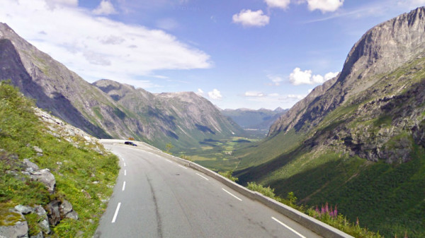
1 Norway – Trollstigen
View via Satellite or view with Streetview
The “Troll’s Footpath” is another fantastic mountain road with a 9% incline and eleven hairpin bends that has won the hearts of tourists – so much so that the local tourist board has built a museum and reception facility there last summer (note that the road is closed between November and May). All those curves are naturally a challenging ride and the nail-biting drops are not for the faint of heart. In terms of scenery, the area features dramatic waterfalls and three rocky peaks known as the King, Queen and the Bishop, all of which are 1.5 kilometres (0.93 miles) high. Look out too for the trolls hiding out in the woods to at the base of the valley (according to at least one road-sign).

Image source: Google Streetview