
The Canadian Rockies aren't just another mountain range on a map. They're a UNESCO World Heritage Site spanning 2.3 million hectares, home to 53 mammal species, over 300 bird species, and some of the most photographed lakes on Earth. In 2025, Banff National Park alone welcomed a record 4.5 million visitors — and yet, most of them clustered around the same three or four spots, leaving vast stretches of wilderness, glacier-fed rivers, and alpine meadows surprisingly empty. Whether you're planning your first visit or your fifth, here are twenty compelling reasons the Canadian Rockies deserve a place on your summer itinerary.
1Banff National Park — Canada's First National Park
Established in 1885 around a cluster of natural hot springs discovered by railway workers, Banff became Canada's first national park and the third in the world. Today it spans 6,641 square kilometres of glacier-carved valleys, turquoise lakes, and jagged limestone peaks. In the 2025 fiscal year, Banff welcomed 4,515,168 visitors — a new all-time record, surpassing 2024 by 7.14%. Frontcountry campgrounds were fully booked throughout the peak summer, totalling 292,033 site nights.
What makes Banff extraordinary isn't just the scenery — it's the accessibility. You can drive from the town of Banff to a glacier viewpoint, a waterfall hike, and a gondola summit all in a single day. The Roam Public Transit system achieved record ridership of 2,294,048 passengers in 2025, a 12% increase over 2024, making it easier than ever to explore without a car.
Roughly 70% of visitors to Banff come from the Calgary region for day use, which means early mornings and late afternoons are when the park feels most tranquil. If you can stay overnight — even just one or two nights — you'll experience a completely different park after the day-trippers head home.
Parks Canada's official Banff page has current trail conditions, shuttle reservations, and campground availability.
2Moraine Lake — The Valley of the Ten Peaks
Moraine Lake is the image that sold the Canadian Rockies to the world. It was featured on the back of the Canadian $20 bill issued in the 1969 "Scenes of Canada" series, and it's been the screensaver on countless Apple devices. The lake sits at 1,910 metres elevation in the Valley of the Ten Peaks, where a near-continuous wall of summits rises above the turquoise water like teeth on a saw blade.
The iconic viewpoint is a 10-minute walk up the Rockpile Trail from the Moraine Lake parking area. The trail is short, well-maintained, and suitable for almost all fitness levels — which is why it gets crowded. Since 2023, Moraine Lake Road has been closed to personal vehicles; you must use the Parks Canada shuttle or a commercial bus. In 2025, 115,019 vehicles were recorded on Moraine Lake Road between June 1 and October 31, a 34% increase over 2023.
The shuttle system had 1,069,351 rides in 2025, and reservations for Lake Louise and Moraine Lake are now combined into a single booking. Reservations open in mid-April and tens of thousands of people join the booking queue within minutes. Book the moment reservations open — this is not an exaggeration.
Moraine Lake's turquoise colour comes from rock flour — microscopic particles of ground stone suspended in the water. As glaciers grind against bedrock, they produce a fine powder that reflects and scatters sunlight, absorbing purples and indigos while scattering blues and greens back to your eyes.
3Lake Louise — The Iconic Turquoise Shore
At 1,750 metres elevation, Lake Louise sits directly below the Victoria Glacier. Standing on the lakeshore, you can trace the cascade of ice and rock from the glacier down to the water, connecting distant snowfields to the ripples at your feet. The Fairmont Chateau Lake Louise, built in 1890 by the Canadian Pacific Railway, anchors the eastern shore and offers canoe rentals, dining, and accommodation right at the water's edge.
Summer parking at Lake Louise costs $42 per day and is often full by sunrise. The Parks Canada shuttle is the practical alternative. From the lakeshore, the Plain of Six Glaciers trail extends 14.2 km round-trip with 591 metres of elevation gain, passing a historic teahouse built in 1924. The Lake Agnes Tea House trail is another classic — 7.4 km round-trip with 400 metres of gain, leading to a second teahouse perched above the lake.
For photographers, sunrise is the golden window. The first rays of light hit Victoria Glacier and gradually transform the lake from a dark mirror to its famous turquoise. By mid-morning, the colour is at its most vivid, but the shoreline is packed. Arrive before 6 AM if you want both the colour and the solitude.
This local's guide to the Plain of Six Glaciers hike has detailed trail conditions and timing advice.
4The Icefields Parkway — The World's Most Scenic Drive
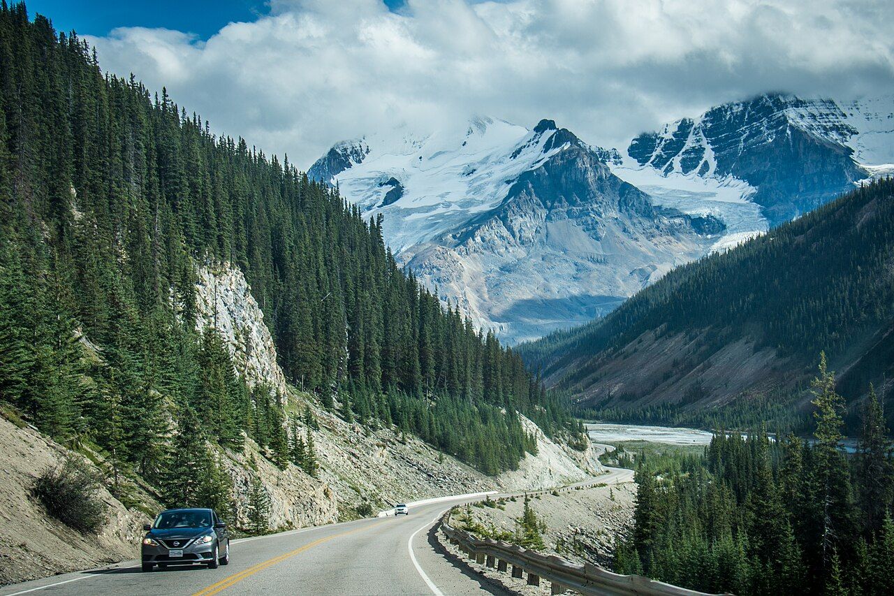
The Icefields Parkway (Highway 93 North) runs 232 kilometres from Lake Louise to the town of Jasper, passing through two UNESCO World Heritage national parks. It skirting the edge of the largest ice field in the Rocky Mountains south of Alaska, delivering a continuous panorama of peaks, glaciers, waterfalls, and turquoise lakes. Driving straight through takes about three hours, but most travellers spend a full day — the scenery keeps pulling you over.
Key stops from south to north include Herbert Lake (6 km from Lake Louise), Crowfoot Glacier viewpoint (36 km), Bow Lake (39 km), Peyto Lake (43 km), Mistaya Canyon (100 km), Saskatchewan River Crossing (108 km — the only fuel between Lake Louise and Jasper), the Columbia Icefield (125 km), Sunwapta Falls (170 km), and Athabasca Falls (200 km).
The highest point on the parkway is Bow Summit at 2,069 metres, where the Peyto Lake viewpoint offers the most photographed single vista on the entire drive. The lake's wolf-head shape and electric blue-green colour are visible from a paved, 2.5-km return walk from the parking area.
Fuel is critical: fill your tank in Lake Louise before joining the parkway. The next fuel stop is 108 km north at Saskatchewan River Crossing. If your tank is less than half full when you reach Saskatchewan River Crossing, fill up — there's nothing else until Jasper.
5Walk on a Glacier — The Athabasca Glacier
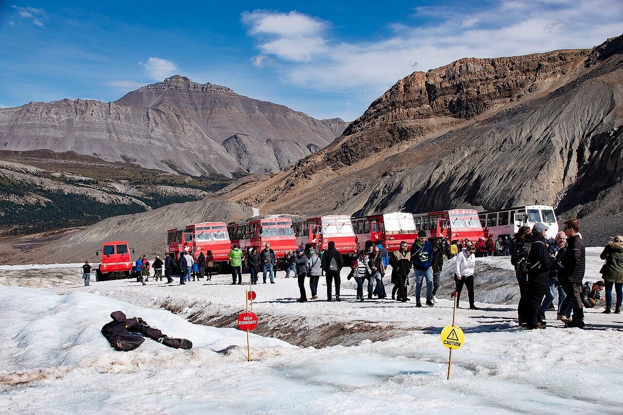
The Athabasca Glacier is one of the most accessible glaciers in the world. It's an outlet of the Columbia Icefield, flowing from about 3,400 metres elevation down to a terminus you can walk to on a marked trail. The glacier is approximately 9.1 km long, covers about 15 km², and ranges in elevation from 1,967 to 3,455 metres. Ice Explorer tours take visitors onto the glacier surface in specially designed six-wheeled vehicles, and a skywalk offers a 280-metre-high glass-floored viewpoint over the Sunwapta Valley.
But the glacier is retreating. The terminus has receded approximately 1.5 km since the mid-19th century, at an average rate of about 5 metres per year. Markers along the access trail show the glacier's position in past decades — standing at the 1990 marker and looking at the current ice edge makes climate change visceral in a way no graph can. The World Glacier Monitoring Service records a mass balance of -0.53 metres water equivalent per year for the 2013–2025 period.
You can also hike the Wilcox Pass trail, which starts across the highway from the Columbia Icefield Discovery Centre. Within 1.6 km of climbing, you reach the famous Parks Canada red chairs with sweeping views of the Athabasca and Dome glaciers. The full trail is 9 km round-trip and takes 3-4 hours.
6The Columbia Icefield — Hydrographic Apex of North America
The Columbia Icefield is the largest ice field in the Rocky Mountains south of Alaska, covering approximately 216 km² as of 2001. It sits atop a triple continental divide — meltwater flows north via the Athabasca River to the Arctic Ocean, east via the North Saskatchewan River to Hudson Bay and the Atlantic, and west via the Columbia River to the Pacific. Standing at the icefield, you're at the hydrographic apex of an entire continent.
Between 1919 and 2009, the Columbia Icefield lost 59.6 km² of ice — a rate of about 0.66 km² per year. The glaciers thinned by an average of 49 metres water equivalent over that period. The Saskatchewan Glacier, the largest outlet, lost 2.8 km³ of ice volume. These aren't abstract numbers; they're the reason the turquoise lakes exist. Without glacial meltwater carrying rock flour, Lake Louise and Moraine Lake would be clear blue, not the surreal turquoise that draws millions.
The Columbia Icefield Discovery Centre, located on the Icefields Parkway at the Banff-Jasper boundary, has interpretive exhibits, a café, and ticket sales for glacier tours. It's also the highest elevation point on the Icefields Parkway, which means weather can change rapidly — carry layers even if it's sunny when you leave Lake Louise.
7Wildlife — 53 Mammal Species and Counting
Banff National Park alone is home to 53 species of mammals, 311 species of birds, 844 plant species, and 19 fish species. The iconic large mammals include grizzly bears, black bears, elk, moose, bighorn sheep, mountain goats, wolves, cougars, and wolverines. The park estimates 65 grizzly bears in Banff, 109 in Jasper, and 11-15 in Yoho — a remarkably dense population for a region so heavily visited.
Elk are the most commonly seen large mammal, with approximately 350 in Banff National Park and over 200 in the lower Bow Valley near the town of Banff. They were nearly extirpated by 1906, but recovered naturally and with help from 235 elk introduced from Yellowstone in 1918-20. During the fall rut (late August to mid-October), bull elk bugle and spar in the townsite meadows — a dramatic but dangerous spectacle. On average, 70 elk die from vehicle or train collisions each year.
Parks Canada requires you to stay 30 metres from elk and 100 metres from bears. Carry bear spray on every hike — it's non-negotiable in bear country. The Bow Valley Parkway (48 km between Banff and Lake Louise) is one of the best wildlife drives; early morning and late afternoon offer the best chances to see elk herds, black bears foraging on berry bushes, and coyotes patrolling meadows.
Parks Canada's wildlife page has species profiles, safety guidelines, and recent wildlife alerts.
Grizzly bears have one of the lowest reproductive rates of all North American land mammals. Females in the mountain parks have cubs every 4-5 years, starting at age 5-8. Cubs are born in the den in late January weighing about half a kilogram, and emerge in spring at around 8 kg.
8Hiking Trails for Every Fitness Level
The Canadian Rockies offer over 1,500 km of maintained trails, ranging from paved valley strolls to multi-day alpine traverses. The key surprise for many visitors is how quickly trails gain elevation — the Plain of Six Glaciers lookout sits over 400 metres above Lake Louise, and Sentinel Pass climbs 730 metres from the Moraine Lake floor. Higher passes may hold snow and avalanche hazard into June, making local trail reports more valuable than map distances.
Easy walks include the Lake Louise lakeshore (flat, paved, 3.3 km one-way), Johnston Canyon lower falls (paved catwalks, 1.1 km one-way), and the Peyto Lake viewpoint (paved, 1.2 km return). Moderate hikes include the Lake Agnes Tea House (7.4 km return, 400 m gain), Stanley Glacier in Kootenay (10 km return, 365 m gain), and Wilcox Pass (9 km return, 150 m gain). Strenuous options include Sentinel Pass (11.6 km return, 730 m gain), the Plain of Six Glaciers (14.2 km return, 591 m gain), and Healy Pass (18.8 km return, 655 m gain — the best wildflower hike in Banff, peaking in late July).
Some trails have seasonal restrictions due to grizzly bear activity. Sentinel Pass and Paradise Valley require groups of four or more adults from mid-July through end of season. Check the Parks Canada trail report before heading out — conditions change rapidly in the mountains.
9The Science Behind the Turquoise — Glacial Rock Flour
The surreal turquoise of Lake Louise, Moraine Lake, Peyto Lake, and Bow Lake isn't paint or minerals — it's physics. As glaciers grind against bedrock, they produce a fine powder of silt and clay called rock flour or glacial flour. These particles are so fine that they remain suspended in the water column rather than sinking. When sunlight hits the water, the particles absorb the shortest wavelengths (purples and indigos), while the water absorbs longer wavelengths (reds, oranges, yellows). What's left to scatter back to your eyes is mainly blue and green — producing that hypnotic turquoise.
But this phenomenon is under threat. As glaciers shrink or disappear, less rock flour flows into the lakes. University of Alberta limnologist Rolf Vinebrooke documented this "clarification" process using archival photographs and sediment core samples. In the span of only a decade or so, some lakes have transitioned from white clay sediments to blackish-brown organic material. The turquoise may become a thing of the past for some lakes within our lifetimes — another reason to visit now rather than later.
The colour is most vivid in late summer (August to early September) when glacial melt is at its peak. In June and early July, some lakes may still be partially frozen or at lower water levels, showing a darker, less saturated hue.
10The Burgess Shale — 500-Million-Year-Old Fossils
The Burgess Shale, located in Yoho and Kootenay National Parks, is one of the most significant fossil sites in the world. It preserves exquisitely detailed soft-bodied marine organisms from the Cambrian explosion — about 508 million years ago — when animal life rapidly diversified. UNESCO inscribed the Burgess Shale as a World Heritage Site in 1981 (later incorporated into the Canadian Rocky Mountain Parks designation) specifically for this scientific value.
Guided hikes to the Burgess Shale quarries operate from June to September and require advance reservations. The Stanley Glacier hike in Kootenay National Park is the most accessible — 10 km return, 365 metres of elevation gain, rated moderate. You can hold a 500-million-year-old fossil in your hand on this trail. The Walcott Quarry hike in Yoho is more strenuous — 22 km return with 760 metres of gain — but passes by Emerald Lake and Takakkaw Falls on the way.
Children under 8 are not recommended on the Stanley Glacier hike, and children 5 and under are not allowed. No pets. A valid national park pass is required. Reservations open in January for the upcoming summer season and fill quickly.
Parks Canada's Burgess Shale guided hike page has schedules, pricing, and reservation details.
11The Banff Gondola — Summit Views Without the Climb
If you want panoramic ridge-line views without committing to a full-day hike, the Banff Gondola whisks you to the summit of Sulphur Mountain (2,281 metres) in eight minutes. A boardwalk trail along the ridge leads to the Sanson's Peak meteorological station, offering 360-degree views of the Bow Valley, Mount Rundle, Cascade Mountain, and the town of Banff far below. The summit building has a restaurant, interpretive exhibits, and a theatre.
For a more active experience, you can hike the Sulphur Mountain trail — 5.5 km one-way with 700 metres of elevation gain — and ride the gondola down (one-way down tickets are available). The trail is well-maintained but relentlessly steep, with switchbacks through forest before breaking into open alpine meadows near the top.
The Jasper SkyTram offers a similar experience in Jasper National Park, ascending to 2,263 metres on The Whistlers. From the upper station, a short trail leads to the summit ridge with views of six mountain ranges, the Columbia Icefield, and the town of Jasper. Both gondolas operate year-round, but summer offers the clearest views and the longest operating hours.
12Johnston Canyon — Waterfalls and Catwalks
Johnston Canyon is one of the most popular hikes in Banff National Park, and for good reason. A paved trail and steel catwalks suspended above Johnston Creek lead through a narrow limestone canyon to two waterfalls — the Lower Falls (1.1 km one-way) and the Upper Falls (2.7 km one-way). At the Lower Falls, you can crawl through a short tunnel to a viewing cave right at the base of the cascade. The Upper Falls thunder 40 metres down a sheer canyon wall.
For those wanting more, the Ink Pots are a further 3 km beyond the Upper Falls — five cold, blue-green mineral springs in an open meadow. The full round-trip to the Ink Pots is about 11.8 km with minimal elevation gain beyond the Upper Falls, making it a good option for families who've already seen the main canyon.
The trail gets very busy — arrive before 9 AM or after 4 PM to avoid the worst crowds. The parking lot often fills by mid-morning in July and August, and overflow parking is a 30-minute walk from the trailhead. Winter is spectacular too — the canyon freezes into an ice-climbing paradise, but summer offers the full force of the water.
13Jasper National Park — Bigger, Wilder, Quieter
Jasper National Park is the largest national park in the Canadian Rockies at 10,878 km² — nearly twice the size of Banff. It receives far fewer visitors, which means more wildlife, quieter trails, and a genuine wilderness feel. The park is home to an estimated 109 grizzly bears, plus black bears, wolves, moose, caribou, and mountain goats. Maligne Lake, at 22 km long, is the largest natural lake in the Canadian Rockies and offers boat cruises to Spirit Island — one of the most photographed spots in Canada.
In late July 2024, a wildfire swept through Jasper, destroying about 30% of the town's structures and forcing the evacuation of the park for most of August. By summer 2025, the town had largely reopened, and signs of regeneration were visible along the Icefields Parkway — fireweed and lodgepole pine seedlings emerging from the blackened forest floor. The resilience of the ecosystem is a powerful thing to witness firsthand.
Maligne Canyon is another must-see — a 50-metre-deep limestone slot canyon with six bridges spanning the gorge at different heights. The lower three bridges are the most dramatic, with the river disappearing into a narrow chasm barely 2 metres wide in places. The full canyon loop is about 3.7 km.
Jasper National Park is a designated Dark Sky Preserve — one of the largest in the world at 11,000 km². The annual Jasper Dark Sky Festival in October draws astronomers and stargazers, but summer nights offer excellent viewing too, with the Milky Way visible to the naked eye.
14Larch Valley — Autumn Gold in the Alps
For a two-to-three-week window — typically the last two weeks of September through the first week of October — the alpine larch trees in the Canadian Rockies turn from green to luminous gold before dropping their needles for winter. It is the single most photographed period in Banff outside of winter, and the planning around it is genuinely competitive. Larch Valley, accessed from Moraine Lake, is the headliner — the largest stand of alpine larches in the area, with Sentinel Pass rising above the golden trees.
The Larch Valley trail is 11.6 km return to Sentinel Pass with 730 metres of elevation gain, taking 4 to 6 hours. A mandatory group-of-four restriction is in effect from mid-July through end of season due to grizzly activity in Paradise Valley. Access requires a Moraine Lake shuttle reservation, which opens in mid-April and sells out within minutes.
If Larch Valley is fully booked, Pocaterra Ridge in Kananaskis Country is the local alternative — 10 km point-to-point with 650 metres of gain, ridge-walking through expansive larch meadows. A Kananaskis Conservation Pass is required for parking. It's what locals do when Larch Valley is shoulder-to-shoulder.
15Natural Hot Springs — Soak After a Hike
The Canadian Rockies exist because of hot springs — it was the discovery of thermal springs on Sulphur Mountain in 1883 by railway workers that led to the creation of Banff National Park. The Banff Upper Hot Springs, located at the base of the Banff Gondola, is the last of nine original springs still open to the public. The water emerges at 37-47°C depending on the season and flows into a restored 1930s-era bathhouse with a mountain-view pool.
In Jasper, the Miette Hot Springs in the Foothills are the hottest in the Canadian Rockies, with water emerging at 53.9°C before being cooled to a comfortable 39°C for the pools. The drive to Miette takes you through the Pocahontas area and past the ruins of an early 20th-century coal mining town. Both facilities are open from May through October and offer day-use fees rather than reservations.
After a long day of hiking, there's nothing quite like soaking in mineral-rich water while looking up at the peaks you just climbed. The Banff Upper Hot Springs is walkable from the town of Banff via a 2.5-km trail, or you can drive and combine it with a gondola ride for a full mountain experience.
16Canoeing on Turquoise Water
Canoeing on Lake Louise or Moraine Lake is expensive — about $145+ per hour — but it's one of the most bucket-list experiences in the Canadian Rockies. Paddling across turquoise glacial water with towering peaks reflected on the surface is the kind of moment that justifies the cost. Go early in the morning when the water is calmest and the reflections are sharpest.
For a more budget-friendly option, the Banff Canoe Club rents canoes for paddling on the Bow River — about $45 per hour with views of Mount Rundle and the Bow Valley. You can also rent boats at Lake Minnewanka, the largest lake in Banff National Park, where a one-hour scenic cruise runs multiple times daily and offers chances to spot bighorn sheep, bald eagles, and occasionally bears along the shoreline.
In Jasper, canoe rentals are available at Pyramid Lake and Patricia Lake, both a short drive from town. The water is calmer and warmer than the glacial lakes near Banff, and the views of the Pyramid Mountain edifice are stunning at sunset.
17Bow Valley Parkway — Cycling and Wildlife
The Bow Valley Parkway (Highway 1A) is a 48-km scenic alternative to the Trans-Canada Highway between Banff and Lake Louise. It's quieter, slower, and far more rewarding for wildlife viewing. Early morning and late afternoon drives often reveal elk herds grazing roadside meadows, black bears foraging on berry bushes, and coyotes patrolling for small mammals.
Parks Canada has extended the Bow Valley Parkway Cycling Pilot for 2025-2030, creating a 17-kilometre cycling route with seasonal vehicle restrictions. Ridership has grown from 63,695 in 2022 to 93,311 in 2025 — a 46% increase — demonstrating strong public support. The restricted section offers a safe, car-free cycling experience through some of the most beautiful valley bottom in the park.
Even if you're not cycling, driving the Bow Valley Parkway instead of the Trans-Canada is worth the extra time. Pullouts at Johnston Canyon, Castle Mountain, and Morant's Curve (the famous CPR railway vista) offer iconic photo opportunities. The speed limit is 60 km/h, which gives you time to actually see the scenery rather than blur past it.
18Peyto Lake — The Wolf-Head Viewpoint
Peyto Lake is the most photographed single viewpoint on the Icefields Parkway, and possibly in all of the Canadian Rockies. From the viewing platform at Bow Summit (2,069 metres — the highest point on the parkway), the lake reveals its extraordinary wolf-head shape and electric blue-green colour. The walk from the parking area to the viewpoint is 2.5 km return on a paved trail, making it one of the easiest ways to experience jaw-dropping alpine scenery without a strenuous hike.
The colour is produced by rock flour from the Peyto Glacier, which feeds the lake. Like all glacial lakes in the Rockies, the colour is most vivid in late summer when meltwater is at its peak. On a calm day, the reflection of the surrounding peaks doubles the visual impact.
Bow Lake, just 4 km south of Peyto Lake on the parkway, is another essential stop. It's the headwaters of the Bow River, which flows through Banff and Calgary and eventually into Hudson Bay. The historic Num-Ti-Jah Lodge, built in 1937 by legendary mountain guide Jimmy Simpson, sits on the lakeshore. A trail from the parking area leads 6.4 km return to the base of Bow Glacier Falls.
19UNESCO World Heritage — 2.3 Million Hectares of Protected Wilderness
The Canadian Rocky Mountain Parks were inscribed as a UNESCO World Heritage Site in 1984, extended in 1990. The designation covers 2,306,884 hectares — encompassing Banff, Jasper, Kootenay, and Yoho National Parks, plus Mount Robson, Mount Assiniboine, and Hamber Provincial Parks. UNESCO cited two criteria: exceptional natural beauty (criterion vii) and the Burgess Shale's outstanding record of Earth's evolutionary history (criterion viii).
The site protects mountain peaks, ice fields, glaciers, alpine meadows, lakes, waterfalls, extensive karst cave systems, thermal springs, and deeply incised canyons. The Columbia Icefield is regarded as the hydrographic apex of North America — headwaters to three major river systems flowing to three different oceans. The area contains 56 recorded mammal species and approximately 280 bird species.
More than nine million people visit the seven parks annually. The Canada Strong Pass, introduced in 2025, offered free entry to all national parks during peak summer and winter periods, making it easier than ever to experience this World Heritage Site. The pass is returning for summer 2026.
UNESCO's official listing for the Canadian Rocky Mountain Parks has the full statement of outstanding universal value.
20Dark Sky Stargazing — The Milky Way at Eye Level
Jasper National Park is one of the world's largest designated Dark Sky Preserves at 11,000 km². At high elevations with minimal light pollution, the Milky Way isn't just visible — it casts shadows. On a clear summer night in Jasper, you can see the Andromeda Galaxy (2.5 million light-years away) with the naked eye, along with satellites, shooting stars, and the occasional aurora borealis dancing over the peaks.
The annual Jasper Dark Sky Festival in October is the flagship event, with guided stargazing, telescope sessions, and astronomy talks. But summer nights — especially July and August when the sky gets truly dark after 11 PM — offer excellent viewing without the festival crowds. Pyramid Lake and Lac Beauvert, both near the town of Jasper, are popular stargazing spots with calm water that doubles the sky's reflection.
Banff is less pristine for stargazing due to light from Calgary and the town itself, but Lake Minnewanka and the Bow Valley Parkway (away from town) still offer dramatically better skies than any urban area. The best technique is simple: let your eyes adjust for 20 minutes without looking at any light source, including your phone. Use a red light if you need to see your surroundings — red doesn't disrupt night vision.
Planning Your Trip
The best time to visit is mid-June through September, when lakes are thawed, trails are mostly snow-free, and all roads are open. July and August are the busiest months — August 2024 saw 793,000 visits to the Alberta Rockies alone. Canadians spent nearly $2 billion visiting the Alberta Rockies in 2024, up 21% from the previous year.
Book accommodations and shuttle reservations months in advance. Moraine Lake shuttle reservations open in mid-April and sell out within minutes. Campgrounds at Banff were fully booked throughout summer 2025 with 292,033 site nights. A park pass is required — about $22 CAD per adult per day, or a Discovery Pass for $151 per family for a full year. The Canada Strong Pass offered free entry in 2025 and is returning for summer 2026.
Carry bear spray on every hike, dress in layers (mountain weather changes rapidly), and always check the Parks Canada trail report before heading out. Most importantly, get off the beaten path — the most memorable experiences in the Canadian Rockies are often found on the trail that nobody else is on.
Frequently Asked Questions
When is the best time to visit the Canadian Rockies?
Mid-June through September offers the best weather, fully open roads, and thawed lakes. July and August are peak season with the warmest temperatures but also the biggest crowds. September offers cooler weather, fewer crowds, and the larch golden season in late September.
Do I need a park pass to visit Banff and Jasper?
Yes, a valid national park pass is required for all visitors. A day pass costs about $22 CAD per adult, or you can purchase an annual Discovery Pass for $151 CAD per family. The Canada Strong Pass offered free entry in 2025 and is returning for summer 2026.
How do I get to Moraine Lake?
Personal vehicles are not permitted on Moraine Lake Road. You must use the Parks Canada shuttle (reservations required, opening in mid-April) or a commercial shuttle operator. Shuttle reservations for Lake Louise and Moraine Lake are now combined into a single booking system.
Is bear spray necessary for hiking in the Canadian Rockies?
Yes, bear spray is essential on every hike. The parks are home to 65 grizzly bears in Banff and 109 in Jasper, plus black bears. Carry bear spray on your belt (not in your pack), know how to use it, and hike in groups when possible. Some trails require groups of four or more during bear season.
How long does it take to drive the Icefields Parkway?
The Icefields Parkway is 232 km from Lake Louise to Jasper. Driving non-stop takes about 3 hours, but most travellers spend a full day (8-10 hours) stopping at viewpoints, lakes, and waterfalls. Fill your fuel tank in Lake Louise — the only fuel stop on the route is at Saskatchewan River Crossing, 108 km in.
Can I visit the Canadian Rockies without hiking?
Absolutely. Many of the most popular attractions are accessible by scenic drives, short walks, gondolas, boat cruises, and viewpoints. Lake Louise, Moraine Lake, Peyto Lake, Johnston Canyon lower falls, Athabasca Falls, and the Banff Gondola all require minimal or no hiking.
What is the Burgess Shale and can I visit it?
The Burgess Shale is a 508-million-year-old fossil site in Yoho and Kootenay National Parks, part of the UNESCO World Heritage designation. Guided hikes operate from June to September with advance reservations required. The Stanley Glacier hike (10 km, moderate) is the most accessible option.
Are the turquoise lakes really that colour in person?
Yes — and often more vivid in person than in photographs. The colour comes from glacial rock flour suspended in the water, which scatters light to produce turquoise. The colour is most intense in late summer (August to early September) when glacial melt is at its peak. Visit early morning for the calmest water and best reflections.


